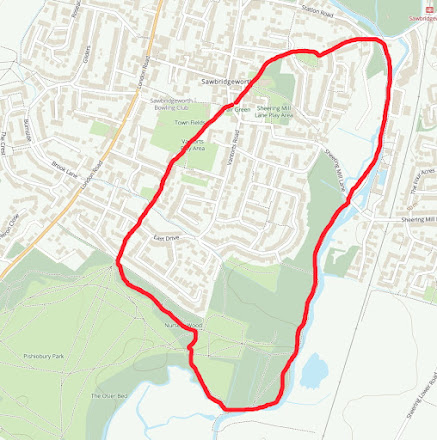
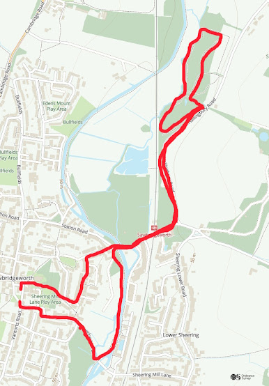
Walk 1. Park and River.
The idea of Nature Walks around Sawbridgeworth Parish is to make people aware of the wonderful wildlife resource we have locally and within walking distance. Each route is shown in a red line on an Ordnance Survey map. Theoretically, all start and finish at the Fair Green but you can of course drop in at any point. Rather then being told what to look for, I have just put pointers in along the route because I want people to look for themselves and make their own discoveries! This will mean much more to everyone! They are not intended as route marches so take your time and stop and look! All the routes follow Footpaths but inevitably, there are places where the walks have to cross roads. Do please take extreme care and follow all the safety guidelines to avoid accidents. County Wildlife sites are marked CWS and a code number.
Walk 1. Park and river. 2.14 miles. Easy walking.
- Start at the Fair Green. Look at the old redbrick wall for lichens and moss.
- Go through the twitchell by the Cricket Field. Note the thick Myrobalan Plum hedge.
- Follow the footpath through Springhall Road down to Bell Mead allotments. Appreciate biodiversity.
- Cross the Sawbridgeworth Brook. Think about where it has come from and where it is going to.
- Taking care, cross Brook Road and follow the narrow path up to Pishiobury Park. Note the thick Hawthorn hedge which is overgrown with ivy. Consider the biodiversity value.
- Enter the Park and turned sharp left into Nursery Wood. Note the range of 1980s plantings and see how many different trees and shrubs. You can identify.
- Halfway down the Wood, its character changes into much older woodland. Have a think about the reasons for this change and identify the trees.
- At the swing gate exit. Turn sharp left into Spring Hall Lane. This could be called a 'holloway', think about how it could have formed.
- Follow the path to the boardwalk alongside the Old River Stort. You are on a floodplain and the field to your left is called Plovers Mead. What you know about the origins of these names?
- Keep on the boardwalk until you reach the Canal. At this point note the pollard willows and the old weirs that used to adjust the water level in the Serpentine lake at Pishiobury.
- Turn left along the towpath. Any ideas how it got its name?
- On your left you will realise there is an area of planted Willow trees. It is assumed that this is an area purchased for carbon capture/offsetting? CWS48/01
- As you leave this area there is a small wood on the left which used to be known as 'The Spinney'. There are coppice Hazel trees which are completely out of place on a floodplain so what are they doing there? Note also the huge hybrid Poplar tree.
- Keep walking and on your left is yet another area for 'carbon capture/offsetting'.
- On your left. There is now the fenced area where it says 'Liable to subsidence'. This is because it used to be first of all, the site of the old sewage treatment works and secondly, the local Town Tip. There are once again hybrid poplars and an Aspen tree which leans over the tow path.
- You will now cross over the backwater which is another segment of the Old River Stort, which has wound its way across the floodplain.
- Take great care crossing Sheering Mill Lane.
- The next point of interest is the 'spillway' which leaves the canal and forms a small and interesting weirpool, which is worth having a look at.
- Opposite the old Maltings buildings you will find a special type of Poplar which is the Balsam Poplar. It has sticky fragrant buds, especially in early spring and used to be much more common, but now the only one that survives is on the river bank.
- Just before County Bridge, there is an overgrown area on the left which is known as Shop Mead. It has a splendid display of Snowdrops in season and has got to be good for biodiversity.
- Now turn sharp left onto Station Road, taking great care and go up the Forebury. Note a range of street trees that must have been planted a long time ago by the local developer.
- Where the Road and path swings around the top of the Forebury there are a line of medium age Ash trees. The hollow has all the appearance of an old gravel pit? It could have been dug to provide material when this area was developed for housing between the World Wars.
- Follow the twitchell through to the churchyard. Noting the school wildlife site on the left and various specimen trees in the churchyard itself.
- You are now back at the Fair Green with some old lime trees which have either been pollarded or 'shredded' which is another way of managing them.
- Please put pictures on the Wildlife Group Facebook page.


Comments
Post a Comment