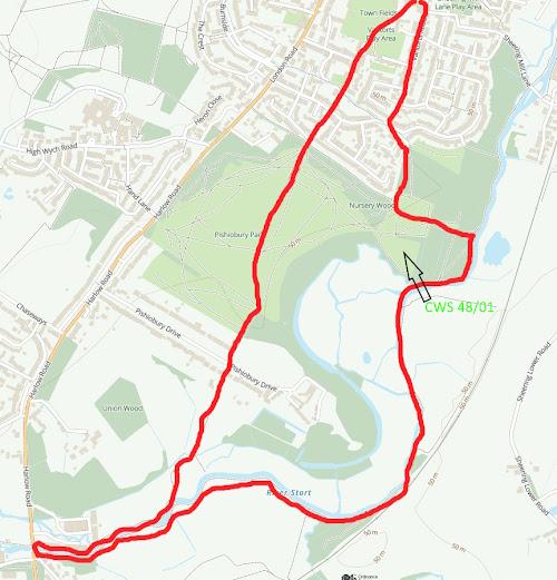
The idea of Nature Walks around Sawbridgeworth Parish is to make people aware of the wonderful wildlife resource we have locally and within walking distance. Each route is shown in a red line on an Ordnance Survey map. Theoretically, all start and finish at the Fair Green but you can of course drop in at any point. Rather then being told what to look for, I have just put pointers in along the route because I want people to look for themselves and make their own discoveries! This will mean much more to everyone! They are not intended as route marches so take your time and stop and look! All the routes follow Footpaths but inevitably, there are places where the walks have to cross roads. Do please take extreme care and follow all the safety guidelines to avoid accidents. County Wildlife sites are marked CWS and a code number.
This Walk will take you through the Bullfields area and then out onto farmland, nearly to Spellbrook, across the railway and then back along the river. Easy walking but can be muddy. 3.7 miles.
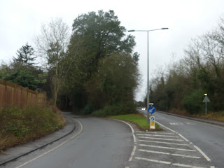
Leave the Fair Green and go into The Square. Walk down Knight Street. Note the Lime tree with Mistletoe opposite the Chinese restaurant. Note also the remaining street Horse Chestnut tree, the large Plane tree on the right and a Eucalyptus on the left .Use the pedestrian crossing at Station Road to go into Bullfields. The green triangle on the right has some interesting trees and a good show of Violets by the wall in the spring.Reedings School has a nice thick hedge for biodiversity as well as a number of trees in the grounds adjacent to the footpath and a newly formed wildlife and seating area.Opposite is the football field, which may well have its usual flock of seagulls. Note the southern age has a strip which is left to go rough and has had some tree and shrub planting. The hedge in the distance, which is along the back of the gardens in, Cambridge Road is a mature hedge which has a good mixture of trees and shrubs.Turn right down Riverfield Lane and then left into Lawrence Avenue noting street trees as you go.Turn sharp left at the end and then immediately right into Cherry Gardens, follow the footpath between the houses out onto the rough field and eventually to the track leading to Kecksy's Farm.Walk down this track for about 50 yards and then turn sharp left to follow the footpath along the back of Northfield House and through to the Cemetery. Note, large specimen trees in the grounds, look for Beech and Walnut.At the end, turn right and then left to go across the end of the Cemetery and then out onto a straight path across arable land. Use binoculars to scan Fox Wood on the right and the roadside belt on the left.At the end of this path you will rejoin the old main road and then have to walk along the roadside path until you reach a footpath in the next layby on the right.Cross this field to the railway noting as you go the Cricket Bat Willow Plantation on the left. CWS 48/019. Taking extreme care cross the railway. Follow the path and you will go over the Tednambury Brook, which flows into the river. The line of the footpath across the field is not very clear, but head for Tednambury Lock. There may be cattle and possibly horses in this field. Look across the floodplain to see Hallingbury Mill in the distance.At the Lock, turn right and follow the tow path. On your left is a Plantation of wet woodland trees including Alder, Aspen and Osier Willow. You will cross the backwater which is the Hallingbury loop and which takes most of the flow of the river.On the right, you will see that the river spurs off which is one of the original channels of the river before the canal was dug. On the resulting island, there is a plantation of Alder trees where you may see Siskins feeding in wintertime.As you go along the tow path you will cross the first of two 'spill ways' which mark the original course of the river creating the high biodiversity backwater 'loops'. In summer look out for Unbranched Bur Reed or Ribbon Weed as well as Yellow Water Lily. There could be a waterweed called Potamogeton in the canal side mouth of the spillway.A short way along on the left you will see the 'Bomb Hole' created in the second World War. It is believed that bombers mistook rivers for wet roads at night.Look on the floodplain on the left and if there has been heavy rain, you may well be able to see the meandering line of one of the original river channels.You will now cross the second 'spillway' and just beyond this is the Sawbridgeworth Marsh Nature Reserve, which can only be accessed from the Hallingbury Road. It features in one of the other Walks.On the other side of the river is a long narrow plantation which was at one time rented by Thomas Rivers in order to grow Sweet Chestnut and Osier Willow for use on the main nursery as poles, stakes and packaging. CWS 48/010 Private.As you go under Kecksy's Bridge, you will notice that there is an excavation alongside the railway embankment. This is a 'borrow dyke' where material would have been dug to build the embankment in the early 19th century when the railway was created. Look out for feral pigeons.You will notice a small triangular field, this is part of Mathams Mead and actually belongs to the meadow that you have just been walking past on the other side of the railway, it was cut off by the railway construction. Note that someone has planted a Eucalyptus tree.On the other side of the river where narrowboats are moored this still remains one large and old pollard willow,which is the last of a whole line of them that used to be here before the days of the narrowboats.Note that the tow path is deliberately lowered at this point, the idea being to allow floodwater out onto the floodplain at times of heavy rain. It acts as a safety valve to prevent flooding further down the river.Look out over the Meadows on your left and you are seeing a very old section of the river valley flood plain. A large area of this is called Mill Fen and local farmers and landowners had rights to cut hay and then graze with cattle. The first section that you walk by on the left is a 'Gated Common' and there used to be a gate on the tow path at the point where you come across the first willow trees on the left. Note a small bed of Common Reed on the opposite bank and a bit further along on the left, find a large and old pollard Oak at the base of the bank where it meets the floodplain.Follow the path and turn right into the development at Burtons Mill adjacent to Sawbridgeworth Lock. This has all the appearance of private land, but is a designated footpath. As you go through the old mill buildings and maltings, find the brickwork and sluices on the right, where the mill wheel used to be and then on the left, the small mill pool.Follow the road up to Station Road and cross over with extreme care into the 'twitchell' which will take you up to the Forebury. At the top note the short run of hornbeam hedge and then cross over following the path by the Fawbert and Barnard wildlife area to enter the churchyard and from here back to the Fair Green.


Comments
Post a Comment